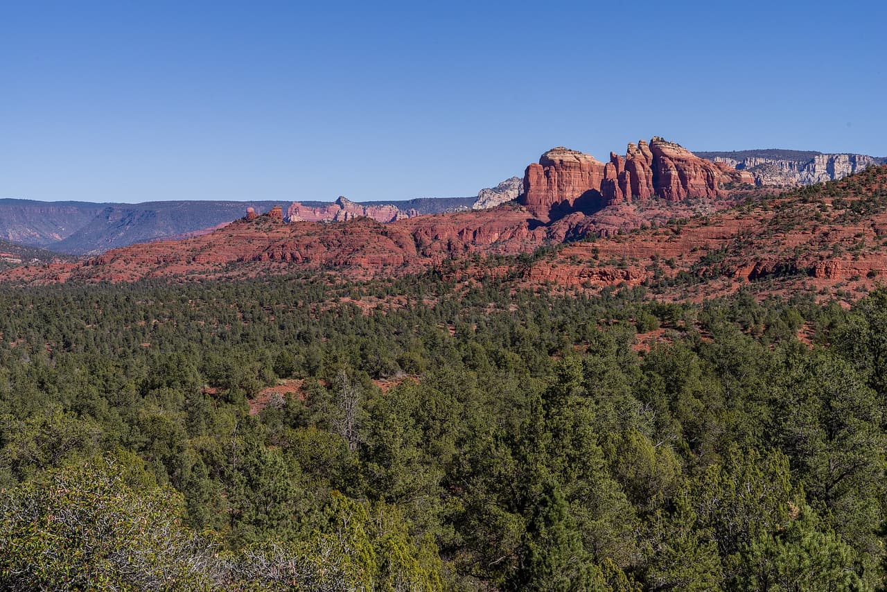
Turkey Creek Trail, Village of Oak Creek
Photo: Coconino National Forest (CC0-1.0) · source

Trails · Village of Oak Creek

Turkey Creek Trail

Length
3.41 mi
Surface
Native material
Trail class
2 of 5, moderately developed

About

Turkey Creek Trail runs about 3.41 miles through the red rock country around the Village of Oak Creek, Arizona. The grade is listed at 5-8%, so there is some climbing but nothing sustained for long. Walkers cross native material. It is signed as trail number 92 and rated trail class 2. The Red Rock Ranger District of the Coconino National Forest takes care of it. Check current conditions before you go, because weather, fire, or repair work can close a route. Carry water and tell someone where you plan to walk.

Last verified by open-data

0 Was this listing useful?
Reviews

What people say

Loading reviews…
Reader notes

Loading notes…

Nearby

Close to Turkey Creek Trail

Red Rock State Park, Village of Oak Creek Peter D. Tillman from USA (CC BY-SA 2.0)
Village of Oak Creek · Parks · 1.3 km

Red Rock State Park is at 4050 Red Rock Loop Rd, managed by Arizona State Parks. The park is open 8 a.m. to 5 p.m. daily, the visitor center runs 9 a.m. to 4:30 p.m., and last entry is 4:30 PM, so arriving late in the afternoon does not work here. Entry is $10 for an adult aged 14 and over, $5 for ages 7 to 13, free for under 7, and $5 to walk in. One thing about our own record: the postal address says Sedona while we file the park under Village of Oak Creek. Call (928) 282-6907 to confirm anything seasonal.

Verified Verified
Sedona · Campgrounds · 2.2 km

A campground at 72 Loy Lane outside Sedona, operated by Global Community Communications Alliance. Wifi is available on site, which is unusual for a camp in this country and useful if you work while you travel. Site types, fees, length limits for a vehicle, and whether water and power are hooked up are not listed here, so ask before you commit to a night. The phone number is (888) 444-1490. Because the camp is run by a private group rather than a public agency, the rules and the booking process are its own, so read them on the camp website first.

Verified Verified
Village of Oak Creek · Trails · 2.7 km

Near the Village of Oak Creek, Arizona, Baldwin Trail covers about 2.52 miles. Grade is 5-8% and the walking surface is native material. The route holds a trail class 3 rating and is numbered 191. It lies in the Coconino National Forest, in the Red Rock Ranger District. Match the trail number to the signs at junctions so you stay on the route you meant to take. Read the rules posted at the trailhead, since not every route is open to bikes, horses, or dogs. Park only in marked spaces and pack out everything you bring in.

Verified Verified
Village of Oak Creek · Trails · 3.1 km

Trail number 115R carries the name Elmerville Spur R Trail. It covers about 1.9 miles on public land near the Village of Oak Creek, Arizona. The route is built on native material and is rated trail class 1. Grade on the path is given as 5-8%. Care of the trail falls to the Red Rock Ranger District of the Coconino National Forest. Carry water and tell someone where you plan to walk. Wear shoes with good grip and give yourself time to get back. Match the trail number to the signs at junctions so you stay on the route you meant to take.

Verified Verified
Village of Oak Creek · Trails · 3.3 km

About 0.42 miles long, Red Rock Crossing Trail sits on Coconino National Forest land near the Village of Oak Creek, Arizona. The Red Rock Ranger District keeps it up. Look for the number 191B where routes meet. The path is made of native material, rated trail class 3, and rises at a grade of 5-8%. Park only in marked spaces and pack out everything you bring in. Phone service is not reliable on forest land, so save a map before you leave town. Plan a turnaround time, and turn back early if the light or the weather changes.

Verified Verified
Village of Oak Creek · Trails

Agave Trail runs about 0.11 miles through the red rock country around the Village of Oak Creek, Arizona. The grade is listed at 5-8%, so there is some climbing but nothing sustained for long. Walkers cross native material. It is signed as trail number 173B and rated trail class 3. The Red Rock Ranger District of the Coconino National Forest takes care of it. Check current conditions before you go, because weather, fire, or repair work can close a route. Carry water and tell someone where you plan to walk.

Verified Verified
Village of Oak Creek · Trails

Baby Bell Spur Trail is 0.32 miles near Village of Oak Creek, in the Red Rock Ranger District of Coconino National Forest. It is trail number 655A. It is a spur, which means it branches off a longer trail and ends rather than looping. The typical grade is 0 to 5 percent, close to flat, and the surface is native material. It is a class 3 trail. The permitted uses are not posted here. Short and flat makes this a reasonable add on at the end of a longer walk, or a way to reach a junction without much climbing.

Verified Verified
Village of Oak Creek · Trails

Trail number 655 carries the name Baby Bell Trail. It covers about 0.28 miles on public land near the Village of Oak Creek, Arizona. The route is built on imported compacted material and is rated trail class 2. Grade on the path is given as 5-8%. Care of the trail falls to the Red Rock Ranger District of the Coconino National Forest. Plan a turnaround time, and turn back early if the light or the weather changes. Check current conditions before you go, because weather, fire, or repair work can close a route.

Verified Verified