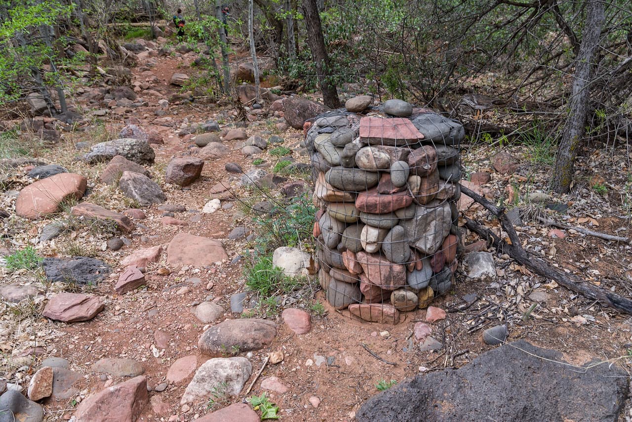
Parsons Trail, Clarkdale
Photo: Coconino National Forest (CC0-1.0) · source

Trails · Clarkdale

Parsons Trail

Length
3.3 mi
Surface
Native material
Trail class
2 of 5, moderately developed

About

Parsons Trail runs 3.3 miles on native material, with grades of 8 to 10 percent, so there is real climbing packed into a fairly short distance. It is rated trail class 2, a built path that still holds loose rock and uneven footing. The route is numbered 144 and is managed by the Red Rock Ranger District of Coconino National Forest. Footwear with grip helps on the steeper pitches. Carry water, because none is posted along the route, and plan turnaround time so you are not finishing in the dark. Check with the ranger district for closures and conditions first.

Last verified by open-data

0 Was this listing useful?
Reviews

What people say

Loading reviews…
Reader notes

Loading notes…

Nearby

Close to Parsons Trail

Clarkdale · Trails · 1.1 km

Packard Trail covers 5.34 miles near Clarkdale, in the Bradshaw Ranger District of Prescott National Forest. It is trail number 0066. The typical grade is 10 to 12 percent, so there is real climbing spread across the distance. The tread is native material; the class is 2. Hiking and horses are listed as allowed uses, and bicycles are not, which usually makes for a quieter trail. At this length, plan for water and for the time of day you will be out in the open. Trailhead directions are not posted or parking details for it, so check with the district office first.

Verified Verified
Clarkdale · Trails · 4.1 km

RR Draw Trail runs 3.27 miles near Clarkdale, in the Bradshaw Ranger District of Prescott National Forest. It is trail number 0068. The typical grade is 10 to 12 percent, so expect sustained climbing rather than a level walk. It is class 2, on native material. Hiking, horses and bicycles are all listed as allowed uses. A draw is a drainage, which means this is a route that follows low ground and can change after storms. There is no listing for conditions or trailhead details, so check with the district office before heading out, especially in monsoon season.

Verified Verified
Clarkdale · Landscaping · 4.7 km

Chowis Scape does landscaping work, with hardscaping and irrigation as the licensed trade. The contractor holds AZ ROC license ROC 351883, classification CR-21 Hardscaping and Irrigation Systems, and it was active when checked on 2026-09-20. That classification covers patios, walls, walkways and watering systems rather than general building. The number is (480) 843-9234. Before hiring, confirm the license is still active and ask that the number appear on the written bid. It also helps to ask how long a job of your size takes, who does the work on site, and what happens if a watering line fails later.

VerifiedROC 351883 Verified
Clarkdale · Tree service · 4.8 km

Climb It High Tree Experts does tree work across the area, serving Clarkdale, Cottonwood, Cornville, Camp Verde, Rimrock and Sedona. Office hours run Monday through Friday from 7 a.m. to 5 p.m., and the crew is closed on Saturday and Sunday. Emergency service is available, which matters after a storm drops a limb on a roof or a driveway. The number is (928) 451-6701. When you call, describe the tree, how close it stands to a building or a power line, and what you want done, because that decides the equipment needed. Ask about the quote and about cleanup and hauling.

Verified Verified
Clarkdale · Plumbers · 4.8 km

Collingwood Pump and plumbing LLC handles water well and pump work. The phone is (928) 202-1973, and hours run every day from 7 a.m. to 6 p.m., weekends included. Emergency service is offered, which matters when a well pump quits and a household loses water. Estimates are free, so it costs nothing to have the problem looked at and priced before deciding. When you call, have the pump type, the depth of the well if you know it, and what changed handy, since that speeds up the answer. Ask what the emergency call carries as a charge outside normal hours.

Verified Verified
More

Also in Trails

All trails in Clarkdale →
Clarkdale · Trails

Bones Trail is 6.05 miles long on native material, so the tread is dirt and rock rather than gravel or pavement. Grades run 5 to 8 percent, which is a steady pull rather than a sharp climb, but the length adds up. It is rated trail class 2, meaning a built path that stays rough in places. The route is numbered 180 and falls under the Red Rock Ranger District of Coconino National Forest. Carry more water than you think you need, since there is no posted water along the way, and check with the ranger district for closures and current conditions before heading out.

Verified Verified
Clarkdale · Trails

Deadman Pocket Trail runs 5.2 miles through the Bradshaw Ranger District of Prescott National Forest, near Clarkdale. It is trail number 0117. The typical grade is 12 to 20 percent, which is the steep end of what we list anywhere in the area, so treat the distance as slower than it looks on paper. Native material underfoot, class 2. Hiking and horses are the allowed uses. Bicycles are not listed. Carry more water than you think you need for a climb this sustained, and check the forest for closures before heading out, because district conditions change with weather and fire.

Verified Verified
Clarkdale · Trails

Deadman Trail is short and steep. It covers 1.59 miles on native material, with grades in the 12 to 20 percent range, so the climbing is sustained for its length. The route is rated trail class 1, the roughest built class, meaning a faint and narrow tread in places where route finding matters. It is open to hiking, horseback riding and bicycles, and is numbered 29 under Kaibab National Forest. Sturdy footwear helps, and a trail map is worth carrying because a class 1 path can be easy to lose. Check with the forest for closures and conditions before you drive out.

Verified Verified